Friday, July 31, 2015

Day 5

We left Jacob Lake Inn rather early to make our way up to Utah and Zion National Park.

37.2026° N, 112.9878° W

Arizona was so incredibly beautiful that I was a little skeptical about Utah.  But I must say, our short time spent in the state did help me to understand their license plate slogan, “Utah – Life Elevated.”  As we traveled through Zion National Park, we were staring straight up into elevated gorgeous cliffs and mountains of stone!  


As we drove, it felt as if we were actually part of the canyon – we were winding and winding through the amazing view!  That is after we were able to get around a rented Cruise America RV that was very scared to drive the curvy switchbacks!  The other cool treat to this national park was the mile long tunnel through one of the orange-red, giant stones – complete with occasional peek-a-boo views to the neighboring boulders on steroids!  I wish we had planned a longer visit at Zion but we had already planned to make our way to Hoover Dam that day.  Maybe another visit, in years to come, will allow further investigations and some hiking.

Passenger seat view - driving into the mile long tunnel.


We continued driving through Springdale, Hurricane and St. George and then back into Arizona for a quick corner of the state before finally making our way into Nevada again. 

I was interested to see the Hoover Dam – I remember touring a small dam in my hometown as an elementary schooler and found it quite fascinating.  Hoover Dam didn’t disappoint but it was HOT!  Ten facts we learned during our Hoover Dam visit:
1) the Colorado River and the water it provided to multiple states was in dispute and had to be resolved before any type of dam could be built
2) the dam provided many during the depression with much needed jobs with the average wage being $4 a day
3) the water is taken from the very deepest part of Lake Mead because fish can’t live that deep and it prevents fish from going into the turbines
4) the building of the dam drew enough people and activity to create it’s own little city – Boulder City
5) the dam was originally named Boulder Dam but later renamed Hoover Dam because of the work J. Edgar Hoover invested into making it happen 
6) the Nevada-Arizona state line runs down the middle of the dam
7) the dam was built in 5 years, a much shorter time than originally projected
8) not only was the dam an engineering marvel for it’s time, it was also built with beautiful art deco details
9) a special refrigeration system piped cold air into tubes in the concrete to cool it and help it harden quicker in the extreme heat of the area
10) it provides a doggone lot of power – okay so I don’t remember that specific wattage detail!


Left: pipe carrying water from Lake Mead  
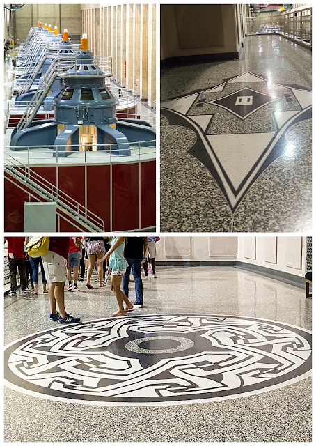
Right: One set of turbines churning I don't even know how many watts of power!
Art Deco designs symbolizing electricity and the water wheel.
Left: The two rectangular buildings house the turbine.
Right: Tunnel leading from underground into the lower levels of the dam.
Left: Original crane used in the construction of the Hoover Dam.
Stateline
View from the top of the dam looking out onto Lake Mead.  We couldn't decide if the water really is that blueish-green color or if it just looked so bright again the contrasting rock.
After our dam visit, we headed to our Vegas hotel – Monte Carlo.  We checked in, settled in and made a quick jaunt down the BLVD to a sandwich shop for dinner.  Let’s just say our first view of the Vegas strip was … a little too enlightening!

Next day – sleeping in!!!

Tuesday, July 28, 2015

Day 4

Day 4 y’all – wow, just wow!

We woke to sounds of train horns along Route 66, prepared for our busy day and after a short drive on the historic route and a few prairie dog sightings; off we went toward the Grand Canyon!

36.0553° N, 112.1218° W

Our Route 66 motel


Entering the park on the south side looks rather mundane except for the occasional elk and mountain lion crossing signs.  (My guy kept saying he would love to see an elk!) It’s the Kaibab National Forest but the vegetation is more shrubby than foresty. And what’s crazy is there is practically no indication as we are driving along that suddenly we are going to find, basically, the world’s largest hole in the ground!!!  We discussed what it may have been like for the first person to ride through this area on horseback thinking they were just going to keep exploring along and then suddenly ride up to this massive, ginormous, giganuous, there-are-no-words-capable-of-describing-its-size canyon! 

Took four pics to capture entire horizon!


Colorado River - wide view and zoom view of the same area.


We jumped on a shuttle for a bit and rode out to several viewing points – all amazing.  We were able to get a glimpse of the Colorado River, which in comparison to the G-R-A-N-D canyon liked much like a brown ribbon weaving through the rock. Truly, the site is unbelievable.


The older two and I took a few minutes to walk down the Bright Angel trail, probably the most popular trail in the Grand Canyon.  CJ was a little spooked by the idea of falling into the canyon so she opted to stay up top with dad!  That’s okay, I was spooked as well about having the three most precious kids in the world near that bigger-than-life canyon.  My palms get sweaty again just thinking about it.  Of course, my teenage son thought it thrilling to get as close as possible to the edges.  YIKES!


We left the main area to start driving to other side of the canyon for our stopping place for the night.  This drive took us through more forest areas and also along part of the canyon that was less popular than the visitor centers areas.  A wonderful drive!  Eventually we saw less canyon and more Kaibab forest.  And then turning a corner we see a couple of cars pulled over – we’re thinking car trouble – and I see it!  I huge elk!!  He was just inside the trees along the roadside.  Of course, we do a U-ey and head straight back for a real live elk viewing.  He was so calm – not at all spooked by us and stared straight into my camera as if saying, “Sure, go ahead, I’m and elk super model!”  My guy got his wish!


Our final destination for the night was Jacob Lake, which probably in reality was about 30 miles directly north of where we stood on the south rim of the canyon; yet we had to drive all the way around the canyon.  But that was sooooo worth it.  It took us through Marble Canyon and was absolutely, positively hold-back-tears stunning!  The colors, the vast and beautiful landscapes – amazing.


Our car climbed and climbed and finally reached the other side of the Grand Canyon to our Jacob Lake pit stop – elevation 7900+ feet!!  We traveled down just a bit to get to the inn so I’m convinced we hit 8000 feet!  Jacob Lake Inn was a super cute, old lodge with some cabins, a few motel rooms and a small two-story hotel.  We reserved the cabin option.  The temp was a COLD 60ish, well, in comparison to the south rim of the Grand Canyon it was cold!


We ate a yummy meal at their dining room, sampled some cookies from their bakery and then bunked up for the night in the cabin. 

Day 4 y’all, Wow, just wow!


Next stop – Utah!

Monday, July 27, 2015

Day 3

We left Anaheim, CA with a slight Disney hangover but started on our way to Arizona – with our first stop at Joshua Tree National Park, CA.

33.7884° N, 115.8982° W

Let’s just say CA traffic was a little chaotic – that alone would be enough for me to avoid living there!!  Regardless, we bobbed and weaved our way out through Corona, Yorba Linda, Riverside, Moreno Valley, Beaumont, and hit Hwy 62 near Palm Springs.   It was at this change in our juncture that we ran smack dab into a ginormous windmill farm – big ones, little ones, older ones, newer ones, giant ones and lots of them!!!


After winding through desert landscape and an occasional home or two we arrived at Joshua Tree and headed to the national park.  I really had no idea what a Joshua tree even  was.  Apparently, it’s not even a tree!!  It’s part of the Yucca plant family.  It earned it’s name from Mormon explorers who first saw it and were reminded of their prophet Joshua because the pseudo tree stood with limbs upraised and they saw them as arms.


Joshua trees dotting the landscape
It's quite obvious why the park has its name!
Anyway, the pseudo trees, while they were plentiful and in various size, weren’t really the highlight of the park (in my humble opinion, of course).  The highlights were the jumbo rocks!  They were huge!  And in amazing piles that looked as if giants had been sitting around the park playing with the rocks and stacking them on top of each other.  In reality, the rock formations were originally formed underground and as plates shifted they started cracking and rising.  Erosion has exposed them over many, many years and has rounded their edges.  Beautifully amazing to see!


Can you see why this area is called Skull Rock?


I picked the perfect day to wear my boots!! Lots of dust and was a little leery of the desert critters I might come in contact with while we galavanted through the park!

So strong!

Getting a little crazy in Joshua Tree National Park!


Skull Rock - pretty cool!
We rode to the peak of the park.  From there, we could see all the way to the Mexico border, various towns, and even the San Andreas fault!!!  Glad it was sleeping while we were there!

It took three pics to capture the horizon!
See the peak in the haze of the pic on the left?  That's around 85 miles away and is the US/Mexico border!
After leaving Joshua Tree National Park, we headed for Arizona.  We entered at Parker, AZ and made our way up to Lake Havasu City, AZ.  The lake was beautiful with the gorgeous red rock hills rising up from the water!  The other point of interest we stopped to gander was the London Bridge!  Yes, I said London.  Story goes – McCulloch, the man who founded Lake Havasu City, decided to bring the bridge all the way from London!  It was originally constructed there in 1831, spanning the river Thames, and then when it was going to be torn down in 1962, McCulloch purchased it from the city of London decided to have it moved to Lake Havasu.  He had each block numbered, shipped over, and then began reconstructing the bridge in 1967.  It was completed in 1971 and still remains in use today connecting Lake Havasu City to an island in the lake.

Traveling to Arizona!

Every town out here labels itself by putting its initial into the rocky hillside!  Had to capture this one - seemed like it was welcoming the Pattersons!

London Bridge - BTW, it's not falling down... we drove across it!
We experienced another first in Lake Havasu City!  Our first visit to In and Out Burger!  Being East Coasters, we just don’t see them – we are used to Five Guys Burgers and Fries.  We do love a good burger though so we were eager to try it.  The verdict: My Guy still likes Five Guys better, Audrey rated it above Five Guys as did Jac, CJ says it’s a “bit” better than Five Guys, and I, most definitely, still rate Five Guys as the highest chain burger.  We all agreed though that In and Out fries have come no where to even being close to the yumminess of Five Guys fries!


We traveled on through Arizona stopping for some gorgeous sunset pics and then stopped for the night on historic Route 66 – staying at the Historic Route 66 Motel.  Thankfully, they had vacancy – especially since I had made our reservations at the Historic Route 66 Motel in NEW MEXICO!!!  Ooooops!

This skyline is the opposite of the sunset - unbelievable!

Arizona sunset


Next stop – Grand Canyon!!